

Main Points In Hindi (मुख्य बातें – हिंदी में)
-
चक्रवात फेंगल की स्थिति: चक्रवात फेंगल वर्तमान में श्रीलंका के त्रिंकोमाली से लगभग 100 किमी दूर स्थित है और इसकी गति धीमी हो गई है, जिससे यह दक्षिण-पश्चिम बंगाल की खाड़ी पर स्थिर हो गया है।
-
मौसमी प्रभाव: आने वाले पश्चिमी विक्षोभ के कारण ऊपरी स्तर की तेज़ हवाएँ चक्रवात के साथ घुलमिल रही हैं, जिससे यह क्षेत्र में मध्यम से भारी वर्षा का कारण बनेगा, विशेषकर तमिलनाडु के तटीय क्षेत्रों में।
-
चक्रवात का विकास: भारतीय मौसम विज्ञान विभाग ने कहा है कि चक्रवात फेंगल का विकसित होना संभव है, हालांकि इसकी पुष्टि बाद में होगी। यह उत्तरी तमिलनाडु और पुडुचेरी के बीच तटों पर पहुँच सकते हैं।
-
हवा की गति: जब चक्रवात कमजोर होकर गहरे दबाव में बदलता है, तो इसकी हवा की गति 50-60 किमी/घंटा से बढ़कर 70 किमी/घंटा तक पहुँच सकती है।
- स्थानीय स्थिति का असर: चक्रवात का प्रभाव स्थानीय मौसम पर पड़ सकता है, जिससे बहारी क्षेत्रों के बजाय तटीय और आंतरिक तमिलनाडु को अधिक लाभ मिल सकता है।
Main Points In English(मुख्य बातें – अंग्रेज़ी में)
Here are the main points regarding Cyclone Fengal based on the provided text:
-
Current Location and Movement: Cyclone Fengal is currently located approximately 100 km east-northeast of Trincomalee, Sri Lanka. It has been moving slowly towards the Tamil Nadu coast, changing its direction to the west-northwest.
-
Development and Conditions: The India Meteorological Department indicates that the deep depression over the Bay of Bengal is expected to weaken and transform into a cyclone. The cyclone is anticipated to develop further, with potential wind speeds reaching up to 70 km/h.
-
Effect of Surrounding Weather: Upper-level fast winds from an incoming western disturbance are interacting with cold sea surface temperatures, which have slowed the development of the cyclone. This situation is likely to result in moderate to heavy rainfall primarily affecting coastal and surrounding interior regions of Tamil Nadu.
-
Expected Impact on Land: The cyclone is expected to make landfall between Karaikal and Mahabalipuram on the northern Tamil Nadu-Puducherry coasts, with weather conditions leading to considerable rainfall in the region.
- Rainfall Forecast: The expected slow movement of the cyclone may lead to significant rainfall, which will mainly benefit the coastal districts of Tamil Nadu.

Complete News In Hindi(पूरी खबर – हिंदी में)
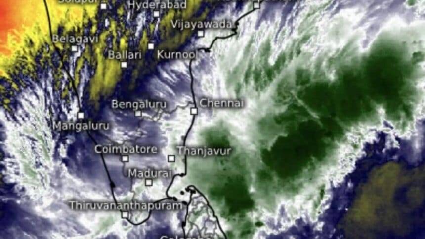
प्रक्षेपित चक्रवात फेंगल कल तक धोखा देने की उम्मीद थी क्योंकि दक्षिण-पश्चिम बंगाल की खाड़ी के ऊपर बने गहरे दबाव ने आग को धीमा कर दिया था और रात में व्यावहारिक रूप से स्थिर रहा। यह श्रीलंका में त्रिंकोमाली से लगभग 100 किमी पूर्व-उत्तरपूर्व में स्थित है; नागपट्टिनम से 320 किमी दक्षिण-पूर्व; पुडुचेरी से 410 किमी दक्षिण-पूर्व; और नवीनतम चेन्नई से 490 किमी दक्षिण-दक्षिण पूर्व में।
उपग्रह चित्रों से पता चला है कि आने वाले पश्चिमी विक्षोभ से ऊपरी स्तर की तेज़ हवाएँ खाड़ी के ऊपर पूर्व-उत्तर-पूर्व की ओर बादलों को काट रही हैं और समुद्र की सतह के ठंडे तापमान के साथ मिलकर गहरे अवसाद को धीमा कर रही हैं। लेकिन यह निरंतर मध्यम से भारी वर्षा के संदर्भ में केवल तटीय और आसपास के आंतरिक तमिलनाडु के लाभ के लिए काम करेगा।
- तमिलनाडु, चेन्नई में बारिश, चक्रवात फेंगल लाइव अपडेट
गहरा दबाव कल श्रीलंका तट से बहुत धीमी गति से आगे बढ़ा और अब यह पश्चिम-उत्तर-पश्चिम से उत्तर-उत्तर-पश्चिम की ओर स्थानांतरित होकर तमिलनाडु तट की ओर उन्मुख हो गया है। यह श्रीलंका तट को छूते हुए उस दिशा में आगे बढ़ना जारी रखेगा और चक्रवात में तब्दील हो जाएगा फेंगल.
भारत मौसम विज्ञान विभाग ने कहा कि चक्रवात के रूप में विकास आज सुबह ही हो सकता है, हालांकि इसकी पुष्टि बाद में ही हो सकती है। चक्रवात कमजोर होकर एक गहरे दबाव में बदल जाएगा और कराईकल और महाबलीपुरम के बीच उत्तरी तमिलनाडु-पुदुचेरी तटों को पार कर सकता है और सुबह 50-60 किमी/घंटा से लेकर 70 किमी प्रति घंटे की रफ्तार तक हवा चल सकती है।
Complete News In English(पूरी खबर – अंग्रेज़ी में)
Here’s a simplified English version:
Cyclone Fengal Expected to Change Course
The cyclone named Fengal is expected to slow down and change its path as a deep depression over the southwest Bay of Bengal has lost some of its intensity. Currently, it is situated about 100 km east-northeast of Trincomalee in Sri Lanka, 320 km southeast of Nagapattinam, 410 km southeast of Puducherry, and 490 km south-southeast of Chennai.
Satellite images indicate that strong upper-level winds from an incoming western disturbance are disrupting clouds over the Bay and combining with cooler sea surface temperatures, which is hindering the deep depression’s development. However, this might lead to continuous moderate to heavy rainfall, primarily benefiting coastal Tamil Nadu and nearby interior areas.
The deep depression has been moving very slowly towards the Tamil Nadu coast and is now shifting from a west-northwest to a north-northwest direction. It is expected to continue in this direction while making landfall on the Sri Lankan coast and could transform into Cyclone Fengal.
The India Meteorological Department has indicated that the cyclone could form as early as this morning, but confirmation is still pending. It may weaken into a deep depression and could cross the northern coast of Tamil Nadu-Puducherry between Karaikal and Mahabalipuram, with wind speeds ranging from 50-60 km/h to potentially 70 km/h in the morning.
Published on November 28, 2024