

Main Points In Hindi (मुख्य बातें – हिंदी में)
यहां लेख के मुख्य बिंदु दिए गए हैं:
-
मौसम पूर्वानुमान: भारत मौसम विज्ञान विभाग (IMD) ने तमिलनाडु, पुदुचेरी, कराईकल और अन्य क्षेत्रों में अत्यधिक भारी बारिश का अनुमान लगाया है, विशेष रूप से बंगाल की खाड़ी में एक मानसून दबाव के निर्माण के कारण।
-
वर्षा का आंकड़ा: हाल ही में आंध्र प्रदेश के कवाली में भारी से बहुत भारी बारिश हुई है, जबकि अन्य क्षेत्रों जैसे नेल्लोर में मध्यम बारिश हुई है।
-
भविष्य के मौसम: IMD ने अगले कुछ दिनों के लिए तटीय आंध्र प्रदेश, तमिलनाडु, केरल और कर्नाटक में भारी बारिश की भविष्यवाणी की है, जो गुरुवार तक जारी रहने की संभावना है।
-
मानसून का परिवर्तन: दक्षिण-पश्चिम मॉनसून का अंत और उत्तर-पूर्वी मॉनसून का आगमन जल्द ही होने की उम्मीद है, जिससे अक्टूबर से दिसंबर तक बारिश शुरू हो सकती है।
- नवीनतम मौसम प्रणाली: बंगाल की दक्षिण-पूर्वी खाड़ी में कम दबाव का क्षेत्र विकसित हो रहा है, जो आने वाले दिन में उत्तरी तमिलनाडु और आस-पास के क्षेत्रों की ओर बढ़ने की संभावना है।
Main Points In English(मुख्य बातें – अंग्रेज़ी में)
Here are the main points from the article:

-
Heavy Rain Forecast: The India Meteorological Department (IMD) has predicted extremely heavy rainfall for Tamil Nadu, Puducherry, Karaikal, and coastal Andhra Pradesh due to a depression forming over the Bay of Bengal.
-
Recent Weather Conditions: Significant rainfall occurred in various regions, particularly in Kavali, with moderate rain noted in Nellore. Other areas such as Kerala, Tamil Nadu, and parts of coastal Andhra Pradesh have also recorded varying amounts of rain.
-
Impact of Cloud Cover: Satellite imagery indicated extensive cloud cover over several states, including Andhra Pradesh, Telangana, and Karnataka, suggesting that light to heavy rains are likely in these regions.
-
Upcoming Weather Patterns: The southwest monsoon is transitioning out, setting the stage for the northeast monsoon, which is expected to bring rains to the southeastern peninsula, including Tamil Nadu and Andhra Pradesh.
- Widespread Rain Predictions: IMD forecasts widespread rain across Kerala, coastal Karnataka, Rayalaseema, and parts of Tamil Nadu over the next few days, with significant rainfall expected to persist into the weekend.
Complete News In Hindi(पूरी खबर – हिंदी में)
गुरुवार को तमिलनाडु, पुदुचेरी और कराईकल और बुधवार को दक्षिण तटीय आंध्र प्रदेश और यनम में और दक्षिण आंतरिक कर्नाटक में अत्यधिक भारी बारिश का अनुमान है क्योंकि भारत मौसम विज्ञान विभाग (आईएमडी) ने बंगाल की खाड़ी को एक दिन में मानसून दबाव के लिए निगरानी में रखा है। जब पश्चिम-मध्य अरब सागर पर एक दूर जा रहा पूर्ववर्ती ओमान तट के करीब चला गया।
सोमवार शाम को समाप्त हुए नौ घंटों में कवाली (तटीय आंध्र प्रदेश और यनम) में अलग-अलग स्थानों पर भारी से बहुत भारी बारिश हुई, जबकि नेल्लोर (5 सेमी) में मध्यम बारिश हुई। अन्यत्र, तमिलनाडु, पुडुचेरी और कराईकल और तटीय आंध्र प्रदेश और यनम के अधिकांश स्थानों और केरल और माहे के कई स्थानों पर अलग-अलग मात्रा में वर्षा दर्ज की गई।
-
पढ़ना: चेन्नई में बारिश: सड़कों पर जलभराव; आईएमडी ने अवसाद के करीब पहुंचने की चेतावनी दी है
विस्तारित कवर किया जा सकता है
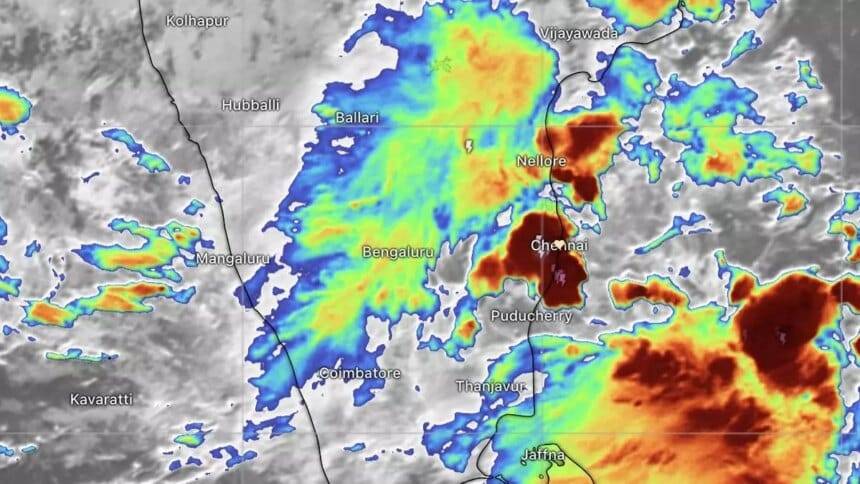
मंगलवार की सुबह सैटेलाइट तस्वीरों में बादल छाए हुए दिखाई दे रहे हैं, जो दक्षिण आंध्र प्रदेश, तेलंगाना, दक्षिण आंतरिक कर्नाटक, रायलसीमा, तटीय आंध्र प्रदेश, तमिलनाडु और मिरयालगुडा, कुरनूल, बेलारी, शिवमोग्गा, नेल्लोर, अंगोला से घिरे केरल में हल्की से मध्यम से भारी बारिश का संकेत दे रहे हैं। चेन्नई, अंबुर, मैसूर और कोझिकोड। मैसूरु, बेंगलुरु, तिरूपति और प्रोद्दातुर जैसे शहर मध्यम से तीव्र बादलों के दायरे में आ गए हैं।
चेन्नई के आसपास के उत्तरी तमिलनाडु तट और पोन्नेरी, सत्यवेदु, अराक्कोनम, तांबरम, कांचीपुरम, चेंगलपट्टू, कलपक्कम, चेयुर, चेटपुट, जिंजी, पोलूर, अरनी, तिरुवेथिपुरम, आर्कोट, वेल्लोर, तिरूपति तक घने बादल छाए हुए देखे गए। , श्रीकालाहस्ती, नायडूपेट, गुडुर, नेल्लोर, कडपा और पड़ोसी तटीय आंध्र प्रदेश और आंतरिक भाग में रायचोटी। भारी बादल तमिलनाडु तट पर खतरे में हैं क्योंकि वे समुद्र के ऊपर अपने आधार से बारी का इंतजार कर रहे हैं।
मंगलवार को तटीय आंध्र प्रदेश और यनम में बहुत भारी बारिश का अनुमान है; तमिलनाडु, पुडुचेरी और कराईकल पर; केरल और माहे; दक्षिण आंतरिक कर्नाटक; और रायलसीमा गुरुवार तक तीन दिनों के लिए; और गुरुवार को तटीय कर्नाटक। यह शुक्रवार को केरल और माहे पर भारी रहेगा; तटीय आंध्र प्रदेश और यनम; तटीय कर्नाटक; और दक्षिण आंतरिक कर्नाटक गुरुवार तक; बुधवार और गुरुवार को उत्तर आंतरिक कर्नाटक; और लक्षद्वीप गुरुवार और शुक्रवार को।
दप मानसून भूमि से बाहर निकल रहा है
इस बीच, दक्षिण-पश्चिम मॉनसून ज़मीन से बाहर निकलने और रिवर्स मॉनसून (उत्तर-पूर्वी मॉनसून) के लिए ज़मीन साफ़ करने से केवल 24 घंटे दूर है। पूर्वी और उत्तर-पूर्वी हवा का शासन दक्षिण प्रायद्वीप और दक्षिण और निकटवर्ती मध्य खाड़ी में स्थापित हो सकता है, जिससे दक्षिण-पूर्व प्रायद्वीप (तमिलनाडु के तट और निकटवर्ती दक्षिण आंध्र प्रदेश) में अक्टूबर से दिसंबर तक बारिश शुरू हो सकती है।
जल्द ही खाड़ी पर डिप्रेशन
मानो संकेत पर, बंगाल की दक्षिण-पूर्वी खाड़ी पर सोमवार का कम दबाव का क्षेत्र पश्चिम-उत्तर-पश्चिम की ओर बढ़ गया और मंगलवार की सुबह दक्षिण खाड़ी के मध्य भागों पर ‘अच्छी तरह से चिह्नित कम’ के रूप में तीव्र हो गया। आईएमडी ने कहा कि इसके अगले दो दिनों के दौरान दबाव में तब्दील होने और उत्तरी तमिलनाडु, पुडुचेरी और आसपास के दक्षिण आंध्र प्रदेश तटों की ओर बढ़ने की संभावना है। एक अन्य चक्रवाती परिसंचरण दक्षिण-पश्चिम खाड़ी और निकटवर्ती तमिलनाडु तट पर है। अरब सागर की ओर, मौसम बनाने वाली एक ट्रफ रेखा मौजूदा दबाव के केंद्र से लेकर दक्षिण केरल तक कोमोरिन तक चली गई।
व्यापक वर्षा का पूर्वानुमान
दक्षिण प्रायद्वीप के लिए एक दृष्टिकोण में, आईएमडी ने केरल और माहे के लिए काफी व्यापक से मध्यम बारिश की भविष्यवाणी की; लक्षद्वीप; पुडुचेरी और कराईकल; केरल और माहे; सप्ताह के दौरान तटीय कर्नाटक और रायलसीमा; अगले तीन दिनों के लिए तमिलनाडु, पुडुचेरी और कराईकल में; और चार दिनों के लिए उत्तरी आंतरिक कर्नाटक, तटीय आंध्र प्रदेश और यनम और दक्षिण आंतरिक कर्नाटक में। यह चार दिनों तक तमिलनाडु, पुडुचेरी और कराईकल में काफी व्यापक से लेकर मध्यम स्तर तक फैला रहेगा; तीन दिनों के लिए उत्तर आंतरिक कर्नाटक और दक्षिण आंतरिक कर्नाटक; और सप्ताह के दौरान तेलंगाना में अलग-थलग से लेकर मध्यम तक।
Complete News In English(पूरी खबर – अंग्रेज़ी में)
On Thursday, heavy rainfall is expected in Tamil Nadu, Puducherry, and Karaikal, while very heavy rainfall is predicted for South Coastal Andhra Pradesh and Yanam, as well as South Interior Karnataka on Wednesday. The India Meteorological Department (IMD) is closely monitoring a weather system in the Bay of Bengal that may bring monsoon conditions, as a weather system has moved away from Oman towards the West-Central Arabian Sea.
In the nine hours ending Monday evening, areas in Kavali (Coastal Andhra Pradesh and Yanam) experienced heavy to very heavy rainfall, while Nellore received moderate rainfall (5 cm). Other regions, including parts of Tamil Nadu, Puducherry, Karaikal, and several locations in Kerala and Mahe, recorded varying amounts of rain.
Looking at Tuesday morning satellite images, cloud cover is indicated in South Andhra Pradesh, Telangana, South Interior Karnataka, Rayalaseema, Coastal Andhra Pradesh, Tamil Nadu, and Kerala, suggesting light to moderate to heavy rain. Cities such as Mysuru, Bengaluru, Tirupati, and Proddatur are expected to experience moderate to intense cloud coverage.
Over the northern Tamil Nadu coast around Chennai, there has been a lot of cloud cover. Areas like Ponneri, Thiruvottriyur, and Tirupati have also shown signs of heavy clouds. The Tamil Nadu coast is under threat as heavy clouds await the rainfall over the sea.
On Tuesday, very heavy rainfall is expected in Coastal Andhra Pradesh, Yanam, Tamil Nadu, Puducherry, Karaikal, Kerala, and parts of South Interior Karnataka, continuing through Thursday. Heavy rains will persist in Kerala and Mahe, Coastal Andhra Pradesh, and Yanam, as well as South Interior Karnataka, with increasing rainfall in Coastal Karnataka on Thursday. Rain is also expected in North Interior Karnataka and Lakshadweep on Wednesday and Thursday.
In the meantime, the Southwest Monsoon is concluding and preparing for the Northeast Monsoon, which could begin soon. Eastern and northeastern winds are expected to dominate the region, potentially leading to rainfall in South-East Peninsula (Tamil Nadu and nearby Southern Andhra Pradesh) from October to December.
Regarding ongoing weather developments, a low-pressure area over the South-Eastern Bay of Bengal intensified Tuesday morning and is expected to track towards Northern Tamil Nadu, Puducherry, and the coast of South Andhra Pradesh in the coming days. Another cyclonic circulation is present over the South-West Bay and the nearby Tamil Nadu coast.
The IMD has forecasted widespread rainfall for the Southern Peninsula, particularly for Kerala, Mahe, Lakshadweep, Puducherry, Karaikal, Tamil Nadu, and various regions over the next few days. Rainfall may vary from moderate to heavy over these areas, with forecasts extending into the week.
Source link