

Main Points In Hindi (मुख्य बातें – हिंदी में)
-
चक्रवात ‘दाना’ की स्थिति: चक्रवात ‘दाना’ ने गुरुवार आधी रात को गंभीर चक्रवात में तब्दील हो गया, और यह ओडिशा के पारादीप से लगभग 260 किमी दक्षिण-पूर्व में स्थित है। इसकी हवा की गति 100-120 किमी/घंटा के बीच बढ़ने की उम्मीद है।
-
भारी बारिश की भविष्यवाणी: आईएमडी ने ओडिशा के कई जिलों में 21 सेमी तक की अत्यधिक भारी बारिश की संभावना जताई है, जबकि पश्चिम बंगाल के कुछ क्षेत्रों में भी हल्की से मध्यम बारिश का अनुमान है।
-
तटों पर तेज़ हवाएँ: ओडिशा और पश्चिम बंगाल के तटों पर गुरुवार से शुक्रवार के बीच तेज़ हवाओं की गति 60-120 किमी/घंटा तक पहुंचने की संभावना है, जिससे भारी नुकसान की आशंका है।
-
समुद्र की स्थिति: चक्रवात के चलते समुद्र की स्थिति ‘उच्च’ से ‘बहुत अधिक’ होने की चेतावनी दी गई है, खासकर ओडिशा-पश्चिम बंगाल तटों पर।
- मछुआरों को चेतावनी: आईएमडी ने मछुआरों को सलाह दी है कि वे तटीय क्षेत्रों में मछली पकड़ने का कार्य न करें और उच्च समुद्र स्थितियों से बचें।
Main Points In English(मुख्य बातें – अंग्रेज़ी में)
Here are 4 main points from the article on Cyclone Dana:
-
Cyclone Intensity and Location: Cyclone Dana intensified into a severe cyclone over the northwestern Bay of Bengal, located approximately 260 km southeast of Paradip, Odisha, as of Thursday morning. The India Meteorological Department (IMD) expects it to maintain its intensity as it approaches the coasts of Odisha and West Bengal.
-
Heavy Rainfall Forecast: The IMD has predicted light to moderate rainfall, with some areas experiencing heavy to very heavy rainfall from Thursday to Friday across several districts in Odisha, including Balasore, Mayurbhanj, and Jajpur, as well as in parts of West Bengal.
-
Strong Winds and Sea Conditions: Wind speeds are expected to increase significantly, reaching up to 120 km/h along the Odisha-West Bengal coasts. The sea conditions are forecasted to deteriorate, with wave heights potentially exceeding 20-46 feet, particularly affecting the coastal areas.
- Warnings for Fishermen and Evacuations: Fishermen have been advised to suspend fishing operations in the northern and central Bay of Bengal. Evacuations are in process, with Odisha deploying 288 rescue teams in anticipation of the cyclone’s impact. Coastal areas may also face flooding due to storm surges of 1.0 to 2.0 meters in height.

Complete News In Hindi(पूरी खबर – हिंदी में)
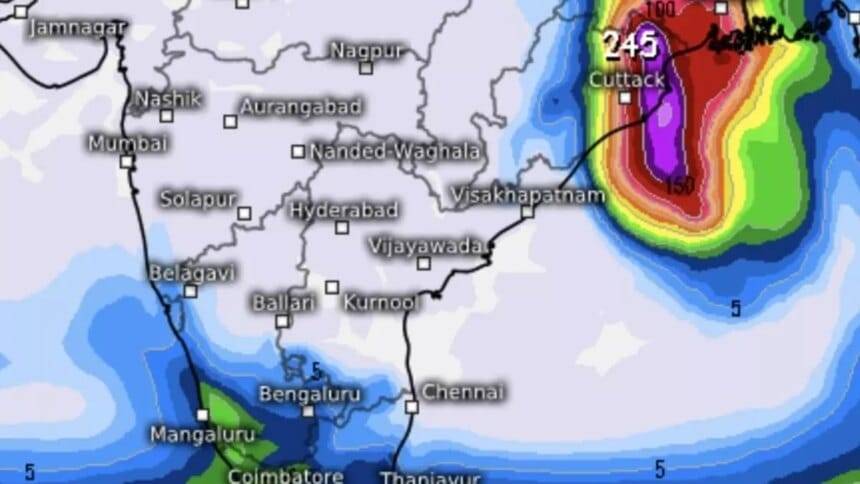
चक्रवात दाना पूर्वानुमान से पहले, गुरुवार आधी रात तक मध्य और निकटवर्ती उत्तर-पश्चिम बंगाल की खाड़ी के ऊपर एक गंभीर चक्रवात में तब्दील हो गया, और गुरुवार की सुबह पारादीप (ओडिशा) से लगभग 260 किमी दक्षिण-पूर्व में उत्तर-पश्चिम और निकटवर्ती मध्य खाड़ी के ऊपर स्थित था। ; धमारा (ओडिशा) से 290 किमी दक्षिण-दक्षिणपूर्व; और सागर द्वीप (पश्चिम बंगाल) से 350 किमी दक्षिण में।
भारत मौसम विज्ञान विभाग (आईएमडी) को इसके और तीव्र होने की उम्मीद नहीं है, और गुरुवार की आधी रात के बीच पुरी और सागर द्वीप के बीच भितरकनिका और धमारा (ओडिशा) के बीच उत्तरी ओडिशा और पश्चिम बंगाल तटों को पार करते समय एक गंभीर चक्रवात के रूप में तीव्रता बनाए रखने की संभावना बरकरार रखी है। और शुक्रवार की सुबह हवा की गति 100-110 किमी/घंटा से बढ़कर 120 किमी/घंटा तक पहुंच गई।
- यह भी पढ़ें: आईएमडी ने तूफान के पूर्वानुमान को गंभीर चक्रवात में बदल दिया है क्योंकि बंगाल की खाड़ी के ऊपर ‘न्यून’ स्तर स्पष्ट रूप से चिह्नित हो गया है
भारी बारिश का अनुमान
आईएमडी ने गुरुवार और शुक्रवार को ओडिशा के बालेश्वर, मयूरभंज, भद्रक, केंद्रपाड़ा, जगतसिंगपुर, केंदुझार, जाजपुर, कटक, ढेंकनाल, खोरदा और पुरी जिलों में अधिकांश स्थानों पर हल्की से मध्यम बारिश और कुछ स्थानों पर भारी से बहुत भारी बारिश की भविष्यवाणी की है। और अलग-अलग स्थानों पर अत्यधिक भारी वर्षा (≥ 21 सेमी) होगी।
इन दिनों पश्चिम बंगाल के दक्षिण और उत्तर 24 परगना, पूर्व और पश्चिम मेदिनीपुर, झाड़ग्राम, हावड़ा, हुगली, कोलकाता और बांकुरा जिलों में अधिकांश स्थानों पर हल्की से मध्यम बारिश का अनुमान है, साथ ही कुछ स्थानों पर भारी से बहुत भारी बारिश होगी। छिटपुट स्थानों पर भारी वर्षा। दक्षिण झारखंड में अधिकांश स्थानों पर हल्की से मध्यम बारिश का भी अनुमान है, गुरुवार को छिटपुट स्थानों पर भारी वर्षा होगी और शुक्रवार को छिटपुट स्थानों पर भारी से बहुत भारी वर्षा होगी।
तटों से तेज़ हवाएँ
गुरुवार की सुबह, ओडिशा-पश्चिम बंगाल तटों पर और उसके आसपास 60-70 किमी/घंटा से लेकर 80 किमी/घंटा की रफ्तार से तूफानी हवाएं चलीं। गुरुवार से शुक्रवार की सुबह तक उत्तर ओडिशा और पश्चिम बंगाल के पूर्वी मेदिनीपुर जिले में हवा की रफ्तार धीरे-धीरे बढ़कर 100-110 किमी प्रति घंटा से बढ़कर 120 किमी प्रति घंटा होने की उम्मीद है। दाना भूस्खलन के लिए घर। गुरुवार शाम से शुक्रवार सुबह तक दक्षिण ओडिशा तट और तटीय पश्चिम बंगाल के शेष जिलों में 60-80 किमी/घंटा से लेकर 90 किमी/घंटा की रफ्तार तक तूफानी हवाएं चलने की संभावना है।
- यह भी पढ़ें: चक्रवात ‘दाना’ के तट की ओर बढ़ने के बीच ओडिशा ने 288 बचाव दल तैनात किए, लोगों को निकाला गया
पानी के ऊपर तूफानी हवाएँ
समुद्र के ऊपर, 95-105 किमी/घंटा की गति से 115 किमी/घंटा की गति तक चलने वाली तूफानी हवाएँ उत्तर-पश्चिम खाड़ी पर हावी रहीं और चक्रवात केंद्र अधिक दूर नहीं था। गुरुवार शाम तक हवा की गति धीरे-धीरे बढ़कर 105-115 किमी/घंटा से बढ़कर 125 किमी/घंटा होने का अनुमान है। 95-105 किमी/घंटा की गति से 115 किमी/घंटा तक की तूफानी हवाएँ सुबह पूर्व-मध्य खाड़ी पर हावी रहीं और दोपहर तक रुक सकती हैं। निकटवर्ती पश्चिम-मध्य खाड़ी में भी हवा की समान गति देखी जा रही है, जिसके दोपहर में कम होने की उम्मीद है।
समुद्र की स्थिति खराब हो गई है
आईएमडी ने चेतावनी दी है कि शुक्रवार की दोपहर तक जब गंभीर चक्रवात आएगा, तब तक ओडिशा-पश्चिम बंगाल के तटों और उसके आसपास समुद्र की स्थिति ‘उच्च’ से बहुत अधिक (लहरों की ऊंचाई 20-46 फीट) होगी। उत्तर-पश्चिमी खाड़ी में भी, जहां से गंभीर चक्रवात भूस्खलन के लिए अंतिम झटका देगा, शुक्रवार की सुबह तक यह ‘उच्च’ से ‘बहुत अधिक’ तक हो सकता है। इस अवधि के दौरान निकटवर्ती उत्तर-पूर्वी खाड़ी में ‘कठिन’ से ‘बहुत कठिन’ स्थितियाँ (8-20 फीट) देखने की संभावना है। पूर्व-मध्य और पश्चिम-मध्य खाड़ी में, जिसे गंभीर चक्रवात गुरुवार को बाद में छोड़ देगा, शाम तक ‘उच्च’ से ‘बहुत उच्च’ स्थिति बनी रह सकती है।
तूफ़ान बढ़ने का ख़तरा
परिणामस्वरूप, खगोलीय ज्वार से 1.0 से 2.0 मीटर की ऊंचाई तक की ऊंचाई वाला तूफान भूस्खलन के समय ओडिशा के केंद्रपाड़ा, भद्रक और बालासोर जिलों और पश्चिम बंगाल के पूर्वी मेदिनीपुर जिले के निचले इलाकों में बाढ़ ला सकता है। इसी तरह, खगोलीय ज्वार से 0.5 से 1.0 मीटर की ऊंचाई तक की वृद्धि से पश्चिम बंगाल के दक्षिण 24-परगना जिले और ओडिशा के जगतसिंहपुर जिले के निचले इलाकों में बाढ़ आ सकती है।
मछुआरों को चेतावनी
आईएमडी ने गुरुवार और शुक्रवार को मध्य और उत्तरी खाड़ी में मछली पकड़ने के संचालन को पूरी तरह से निलंबित करने की सलाह दी। उन्हें सलाह दी जाती है कि वे पूर्व-मध्य खाड़ी और निकटवर्ती पश्चिम-मध्य खाड़ी में भी न जाएं। उन्हें शुक्रवार तक उत्तर-पश्चिम और निकटवर्ती उत्तर-पूर्वी खाड़ी और ओडिशा, पश्चिम बंगाल और बांग्लादेश तटों के आसपास जाने से बचना चाहिए।
Complete News In English(पूरी खबर – अंग्रेज़ी में)
On Thursday midnight, Cyclone Dana intensified into a severe cyclone over the central and nearby northwestern Bay of Bengal before the forecast was issued. By Thursday morning, it was located approximately 260 km southeast of Paradip (Odisha), 290 km south-southeast of Dharmara (Odisha), and 350 km south of Sagar Island (West Bengal).
The India Meteorological Department (IMD) does not expect the cyclone to intensify further. However, it maintains the possibility of it crossing the northern Odisha and West Bengal coasts as a severe cyclone between Puri and Sagar Island late Thursday night and remaining so until Friday morning, with wind speeds increasing from 100-110 km/h to 120 km/h.
- Also Read: IMD upgrades the storm forecast to severe cyclone as a ‘low’ pressure level is clearly marked over the Bay of Bengal.
Heavy Rainfall Expected
IMD has predicted light to moderate rain in most areas of Odisha’s Balasore, Mayurbhanj, Bhadrak, Kendrapara, Jagatsinghpur, Keonjhar, Jajpur, Cuttack, Dhenkanal, Khurda, and Puri districts on Thursday and Friday, with heavy to very heavy rainfall in some areas and extreme heavy rainfall (≥ 21 cm) in isolated places.
In West Bengal’s South and North 24 Parganas, East and West Medinipur, Jhargram, Howrah, Hooghly, Kolkata, and Bankura districts, light to moderate rain is also expected, along with heavy to very heavy rain at a few locations. Light to moderate rainfall is forecasted for many areas in southern Jharkhand, with isolated heavy rain on Thursday and heavy to very heavy rain on Friday.
Strong Winds along Coasts
As of Thursday morning, stormy winds gusting between 60-70 km/h to 80 km/h were recorded along and around the Odisha-West Bengal coasts. From Thursday to Friday morning, wind speeds are expected to gradually increase to 100-110 km/h, reaching up to 120 km/h in East Medinipur, West Bengal. Strong winds of 60-80 km/h to 90 km/h are anticipated along the southern Odisha coast and the remaining districts of coastal West Bengal from Thursday evening until Friday morning.
- Also Read: With Cyclone ‘Dana’ approaching, Odisha has deployed 288 rescue teams and evacuated residents.
Stormy Conditions Over Water
Over the sea, stormy winds were prevalent with speeds ranging from 95-105 km/h to 115 km/h in the northwestern Bay of Bengal, with the cyclone center not far off. By Thursday evening, wind speeds are expected to increase from 105-115 km/h to about 125 km/h. In the eastern-central bay, winds of 95-105 km/h to 115 km/h have been observed and may subside by afternoon. Similar wind conditions are also noted in the nearby western-central bay, which is expected to decrease by afternoon as well.
Sea Conditions Expected to Deteriorate
IMD has warned that by Friday afternoon, when the severe cyclone makes landfall, sea conditions along and around the Odisha-West Bengal coasts may reach ‘high’ to very high levels (with wave heights of 20-46 feet). Similarly, in the northwestern bay, where the cyclone will strike, conditions could escalate from ‘high’ to ‘very high’ by Friday morning. During this time, the northeastern bay may see ‘rough’ to ‘very rough’ conditions (with wave heights of 8-20 feet). The east-central and west-central bays, which will be affected by the cyclone later on Thursday, may also maintain ‘high’ to ‘very high’ conditions through the evening.
Risk of Storm Surge
As a result, a storm surge with a height of 1.0 to 2.0 meters could lead to flooding in low-lying areas of Odisha’s Kendrapara, Bhadrak, and Balasore districts, and East Medinipur district in West Bengal when the cyclone makes landfall. Additionally, an increase of 0.5 to 1.0 meters due to the tidal surge might cause flooding in low-lying areas of South 24 Parganas in West Bengal and Jagatsinghpur district in Odisha.
Warnings for Fishermen
IMD has advised a complete suspension of fishing operations in the central and northern bay on Thursday and Friday. Fishermen are advised to stay away from the eastern-central and nearby western-central bay as well. They should avoid the northwestern and northeastern bay, as well as the coasts of Odisha, West Bengal, and Bangladesh until Friday.