

Main Points In Hindi (मुख्य बातें – हिंदी में)
-
चक्रवात "दाना" का प्रभाव: चक्रवात "दाना" ने उत्तर-पश्चिम बंगाल की खाड़ी से उत्तर-उत्तरपश्चिम की ओर बढ़कर ओडिशा के उत्तरी तट को प्रभावित किया, जहां हवाओं की गति 100-120 किमी/घंटा तक पहुंच गई।
-
भविष्यवाणी और ट्रैकिंग: भारतीय मौसम विज्ञान विभाग (IMD) ने सफलतापूर्वक चक्रवात की दिशा और समय का अनुमान लगाया था। "दाना" धीरे-धीरे कमजोर होकर चक्रवात में बदलने की आशंका है।
-
बारिश का पूर्वानुमान: ओडिशा और पश्चिम बंगाल में हल्की से मध्यम बारिश की संभावना है, कुछ स्थानों पर भारी बारिश की चेतावनी दी गई है।
-
घातक प्रकोप की तैयारी: पश्चिम बंगाल और ओडिशा ने चक्रवात से पहले लाखों लोगों को राहत शिविरों में منتقل किया है, जिससे संभावित नुकसान को कम करने में सहायता मिल सके।
- पूर्वोत्तर मानसून की पुनर्स्थापना: चक्रवात के बाद, उत्तर-पूर्वी मानसून के नवंबर के पहले सप्ताह में पुनर्जीवित होने की संभावना है, जिससे तमिलनाडु तट पर बारिश की शुरुआत हो सकती है।
Main Points In English(मुख्य बातें – अंग्रेज़ी में)
Here are the main points regarding the severe cyclone Dana based on the provided article:
-
Cyclone Landfall and Wind Speeds: Cyclone Dana made landfall near the north Odisha coast between 1:30 AM to 3:30 AM on Friday, with wind speeds escalating from 100-110 km/h to 120 km/h.
-
Tracking and Predictions: The Indian Meteorological Department (IMD) accurately predicted the cyclone’s path, and Dana is expected to weaken to a cyclonic storm as it moves northwest. Continuous monitoring is being conducted via Doppler radar in Paradip.
-
Impact on Weather: The cyclone is anticipated to bring heavy rains, ranging from light to extremely heavy in several areas across Odisha, with wind speeds of 60-80 km/h in southern Odisha and up to 120 km/h in eastern Medinipur, West Bengal.
-
Conditions Across Regions: Significant rainfall is expected in a wide area, including Balasore, Mayurbhanj, and various districts in West Bengal, indicating potential flooding and disruption.
- Post-Cyclone Weather Changes: The remnants of Cyclone Dana are predicted to create weather changes across southern Jharkhand, southern Bihar, and northern Andhra Pradesh, with the northeast monsoon likely to revive in early November, leading to further rainfall in southern parts of the Indian peninsula.

Complete News In Hindi(पूरी खबर – हिंदी में)
भीषण चक्रवात दाना उत्तर-पश्चिम बंगाल की खाड़ी उत्तर-उत्तरपश्चिम की ओर बढ़ी और शुक्रवार की सुबह 1.30 बजे से 3.30 बजे के बीच हबलीखाती नेचर कैंप (भितरकनिका) और धमारा के करीब उत्तरी ओडिशा तट को पार कर गई, जैसा कि भारत मौसम विज्ञान विभाग (आईएमडी) ने भविष्यवाणी की थी। हवा की गति 100-110 किमी/घंटा से बढ़कर 120 किमी/घंटा तक पहुंच जाती है।
भीषण चक्रवात बिना ताकत खोए देर रात 2.30 बजे ओडिशा तट पर, पारादीप से लगभग 60 किमी उत्तर-पूर्व और धमारा (दोनों ओडिशा) से 20 किमी दक्षिण-पूर्व और सागर द्वीप (पश्चिम बंगाल) से 150 किमी दक्षिण-पश्चिम में केंद्रित था। ). एक घंटे बाद, यह धमारा से लगभग 10 किमी उत्तर में और हबलीखाती नेचर कैंप (भितरकनिका) से 20 किमी उत्तर-उत्तर-पश्चिम में चला गया था।
सफल ट्रैकिंग
भूस्खलन का ट्रैक, समय और स्थान बिल्कुल आईएमडी द्वारा भविष्यवाणी की गई रेखाओं पर थे, जो क्षेत्र में इसकी विशेषज्ञता का एक और उदाहरण प्रदान करता है। भूस्खलन के बाद, दाना इसके उत्तरी ओडिशा में पश्चिम-उत्तरपश्चिम की ओर बढ़ने और शुक्रवार दोपहर तक धीरे-धीरे कमजोर होकर चक्रवात में बदलने की उम्मीद है। यह प्रणाली पारादीप में डॉपलर मौसम रडार द्वारा निरंतर निगरानी में है।
-
पढ़ें: पश्चिम बंगाल और ओडिशा ने चक्रवात से पहले लाखों लोगों को चक्रवात आश्रयों और राहत शिविरों में स्थानांतरित किया दानाका भूस्खलन
दाना शाम तक कमजोर होकर गहरे दबाव और रात में दबाव में बदलने की उम्मीद है। शुक्रवार को सुबह तक उत्तरी ओडिशा और पश्चिम बंगाल के पूर्वी मेदिनीपुर जिले में 100-110 किमी/घंटा और 120 किमी/घंटा की रफ्तार से तूफानी हवाएं चल सकती हैं। इसी अवधि के दौरान दक्षिण ओडिशा और शेष तटीय पश्चिम बंगाल में हवा की गति 60-80 किमी/घंटा के बीच और 90 किमी/घंटा तक पहुंच सकती है।
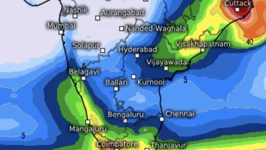
ओडिशा, बंगाल में बारिश
का कमजोर चरण दाना शुक्रवार को आंतरिक ओडिशा के अधिकांश स्थानों पर हल्की से मध्यम बारिश, कुछ स्थानों पर भारी से बहुत भारी बारिश और अलग-अलग स्थानों पर अत्यधिक भारी बारिश हो सकती है। क्षेत्र में 40-50 किमी/घंटा और 60 किमी/घंटा की गति से तेज़ हवाएँ चल सकती हैं और दोपहर से शनिवार की सुबह तक 50-60 किमी/घंटा से 70 किमी/घंटा तक की तेज़ हवाएँ चल सकती हैं।
-
ये भी पढ़ें: चक्रवात दाना: कोलकाता हवाईअड्डे ने उड़ान परिचालन निलंबित किया, रेलवे ने सक्रिय कदम उठाए
बालेश्वर, मयूरभंज, भद्रक, केंद्रपाड़ा, जगतसिंगपुर, केंदुझार, जाजपुर, कटक और ओडिशा के ढेंकनाल, खोरदा और पुरी जिलों में अधिकांश स्थानों पर हल्की से मध्यम बारिश होने का अनुमान है, कुछ स्थानों पर भारी से बहुत भारी बारिश होगी और बहुत भारी बारिश होगी( ≥ 21 सेमी) शुक्रवार को पृथक स्थानों पर। पड़ोसी राज्य पश्चिम बंगाल के दक्षिण और उत्तर 24 परगना, पूर्व और पश्चिम मेदिनीपुर, झाड़ग्राम, हावड़ा, हुगली, कोलकाता और बांकुरा जिलों में भी ऐसी ही स्थिति रहेगी।
दाना अवशेष का ट्रैक
दक्षिणी झारखंड और दक्षिणी बिहार में अधिकांश स्थानों पर हल्की से मध्यम बारिश, कुछ स्थानों पर भारी से बहुत भारी बारिश और अलग-अलग स्थानों पर अत्यधिक भारी बारिश होने की संभावना है। अनुमान है कि चक्रवात का एक अवशेष ओडिशा और उत्तरी आंध्र प्रदेश तट से नीचे खिसकेगा, प्रायद्वीप के उत्तरी हिस्सों से पश्चिम की ओर बढ़ेगा और गोवा तट से दूर अरब सागर में प्रवेश करेगा। फिलहाल हवाएं दक्षिण-पश्चिमी हैं और अगले कुछ दिनों तक केरल और तमिलनाडु के दक्षिणी हिस्सों में बारिश होती रहेगी।
पूर्वोत्तर मानसून पुनर्जीवित होने के लिए तैयार है
संख्यात्मक मॉडल भविष्यवाणियों के अनुसार, गंभीर चक्रवात से बाधित होने के बाद, उत्तर-पूर्वी मानसून नवंबर के पहले सप्ताह से बंगाल की खाड़ी में पुनर्जीवित हो सकता है। बाद में अपनी ताकत स्थापित करने से पहले यह तमिलनाडु तट पर संगठित बारिश ला सकता है। जलवायु पूर्वानुमान प्रणाली मॉडल के अनुसार, 13 नवंबर से 22 नवंबर तक दक्षिण प्रायद्वीप में भारी बारिश हो सकती है और दिसंबर की शुरुआत तक, जब पूर्वानुमान उपलब्ध होंगे, तीव्रता में थोड़ी कमी आ सकती है।
Complete News In English(पूरी खबर – अंग्रेज़ी में)
Severe cyclone Dana hits north Odisha coast with heavy rain and strong winds
A powerful cyclone named Dana has made its way across the northwestern Bay of Bengal and hit the northern Odisha coast between 1:30 AM and 3:30 AM on Friday. This was anticipated by the India Meteorological Department (IMD). The wind speeds increased from 100-110 km/h to 120 km/h.
At around 2:30 AM, the cyclone remained strong and was located about 60 km northeast of Paradip, 20 km southeast of Dhamaara, and 150 km southwest of Sagar Islands in West Bengal. An hour later, it moved 10 km north of Dhamaara and 20 km north-northwest of the Hablikhati Nature Camp in Bhitarkanika.
Tracking Success
The path, timing, and location of the cyclone matched IMD’s predictions, showing their expertise in the region. It is expected that Dana will weaken gradually and transform into a depression by Friday afternoon, moving west-northwest across northern Odisha. The system is under constant watch by Doppler radar in Paradip.
Dana is likely to weaken into a deep depression by evening, and the region can expect stormy winds ranging from 100-110 km/h in northern Odisha and parts of East Midnapore in West Bengal. Other areas may see wind speeds of 60-80 km/h, potentially reaching 90 km/h.
Rain in Odisha and Bengal
As Dana weakens, light to moderate rain is expected across most parts of inland Odisha, with heavy rainfall in some areas. Strong winds can be anticipated at speeds of 40-50 km/h, increasing to 50-60 km/h or 70 km/h by Saturday morning.
In districts such as Balasore, Mayurbhanj, Bhadrak, Kendrapada, and Jagatsinghpur in Odisha, moderate to heavy rain is expected, with isolated places receiving very heavy rainfall (≥21 cm). Similar weather conditions are anticipated in neighboring districts of West Bengal.
Path of the remnants of Dana
The remnants of the cyclone could lead to light to moderate rainfall in southern Jharkhand and southern Bihar, with heavy rainfall in some areas. It is anticipated that the remnants will slide down from Odisha and the northern Andhra Pradesh coast, moving westward and entering the Arabian Sea near Goa. For now, the winds are southwest and may bring rain to southern Kerala and Tamil Nadu over the next few days.
Northeast Monsoon Expected to Revive
According to numerical model forecasts, the northeast monsoon is likely to revive in the Bay of Bengal from the first week of November, after the disturbances caused by the severe cyclone. It may initially bring organized rainfall to the Tamil Nadu coast. Climate prediction models suggest that heavy rainfall is anticipated in the southern peninsula between November 13 and November 22, with a slight reduction in intensity before the beginning of December when more forecasts will be available.