

Main Points In Hindi (मुख्य बातें – हिंदी में)
यहाँ पर दी गई जानकारी के मुख्य बिंदु निम्नलिखित हैं:
-
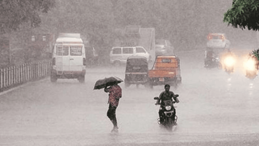
मौसम विभाग की जानकारी: भारतीय मौसम विभाग (IMD) ने बताया कि बंगाल की खाड़ी में एक निम्न दबाव क्षेत्र विकसित हुआ है, जो उत्तरी-पश्चिम दिशा में बढ़ते हुए एक अवसाद में बदल गया है। यह 17 अक्टूबर को सुबह चेन्नई के करीब पुडुचेरी और नेल्लोर के बीच लैंडफॉल करेगा।
-
तूफानी हवाएँ और भारी बारिश: 17 अक्टूबर तक, दक्षिणी भारत के तमिलनाडु, पुडुचेरी, और दक्षिण आंध्र प्रदेश के तटों पर औसत 60 किमी प्रति घंटे की गति से हवा चल सकती है, जिससे कुछ स्थानों पर भारी से बहुत भारी बारिश होने की संभावना है।
-
आंध्र प्रदेश में बारिश की स्थिति: निम्न दबाव क्षेत्र के कारण आंध्र प्रदेश के कई हिस्सों में भारी बारिश हुई है, जैसे नेल्लोर जिले में कावली में 15 सेमी, अदकी में 14 सेमी बारिश दर्ज की गई है।
-
मछुआरों के लिए चेतावनी: आंध्र प्रदेश राज्य आपदा प्रबंधन प्राधिकरण ने लोगों को सतर्क रहने की सलाह दी है और मछुआरों को समुद्र में नहीं जाने की सलाह दी गई है, क्योंकि तट पर 55 किमी प्रति घंटे की गति से तेज हवाएँ चलने की संभावना है।
- नवीनतम मौसम पूर्वानुमान: ग्रेटर गोदावरी, एलुरु, कृष्णा, और अन्य जिलों में भारी बारिश का अनुमान है, और मौसम में परिवर्तन 18 अक्टूबर से होने की उम्मीद है।
Main Points In English(मुख्य बातें – अंग्रेज़ी में)
Here are the main points from the provided text:

-
Formation and Movement of Low Pressure: The India Meteorological Department (IMD) reported that a low pressure area in the Bay of Bengal has developed into a depression, located 490 km south-east of Chennai. It is expected to make landfall on the Tamil Nadu-South Andhra Pradesh coasts on the morning of October 17.
-
Weather Forecast: Heavy to very heavy rains are anticipated in parts of Tamil Nadu and Andhra Pradesh, with wind speeds reaching up to 60 km/h expected over the southwest and adjacent areas of the Bay of Bengal by October 17. The weather is projected to improve after Thursday.
-
Rainfall Reports: Several regions in Andhra Pradesh have already experienced significant rainfall due to the low pressure area, with areas like Kavali and Adki recording over 14 cm of rain. Continued heavy rainfall is expected in various districts including Guntur and Nellore.
-
Safety Warnings: The Andhra Pradesh State Disaster Management Authority has warned of potential heavy rainfall and strong winds in several districts. Fishermen have been advised to refrain from going to sea due to dangerous conditions.
- Geographical Impact: The weather system is predicted to affect various coastal areas, including Tamil Nadu and regions of Andhra Pradesh, highlighting the broad impact of the depression formation on local weather patterns.
Complete News In Hindi(पूरी खबर – हिंदी में)
भारत के मौसम विज्ञान विभाग (IMD) ने कहा है कि दक्षिण-पश्चिम और लगे हुए दक्षिण-पूर्व बंगाल की खाड़ी में बने कम दबाव के क्षेत्र ने मंगलवार शाम को एक अवसाद में बदल गया है। यह प्रणाली बंगाल की खाड़ी के दक्षिण-पश्चिम में, चेन्नई के दक्षिण-पूर्व में 490 किलोमीटर और नीलोर के दक्षिण-पूर्व में 590 किलोमीटर स्थित है, और यह 17 अक्टूबर की सुबह पुडुच्चेरी और नीलोर के बीच तमिलनाडु-दक्षिण आंध्र प्रदेश तटों पर पहुंचने की संभावना है।
ताकतवर हवाएं चलेंगी!
मौसम विभाग के अनुसार, बुधवार को राज्य के कुछ स्थानों पर भारी से बहुत भारी बारिश होने की संभावना है। 17 अक्टूबर तक, दक्षिण-पश्चिम और लगे हुए पश्चिम-मध्य बंगाल की खाड़ी सहित तमिलनाडु, पुडुच्चेरी और दक्षिण आंध्र प्रदेश के तटों पर हवाओं की गति 60 किलोमीटर प्रति घंटे तक पहुंच सकती है। मौसम उम्मीद है कि गुरुवार के बाद धीरे-धीरे सामान्य होगा।
इन स्थानों पर बारिश दर्ज की गई
पूर्व में, बंगाल की खाड़ी में बने कम दबाव के क्षेत्र के कारण आंध्र प्रदेश के कई हिस्सों में भारी बारिश हुई थी। यह कम दबाव का क्षेत्र दक्षिण-पूर्व से पश्चिम और उत्तर-पश्चिम की ओर बढ़ा। मौसम विभाग ने मंगलवार को तटीय आंध्र प्रदेश और यानम में भारी बारिश की भविष्यवाणी की थी।
इसी के साथ पढ़ें – दक्षिण पश्चिम मानसून: लौटते मानसून ने एमपी में धान और सोयाबीन की फसलों को नष्ट किया।
रेयालसिमा क्षेत्र में भी ऐसे ही मौसम की उम्मीद थी और मंगलवार सुबह तक कई स्थानों पर भारी बारिश हुई। नीलोर ज़िले में, कावाली ने 15 सेंटीमीटर, आदकी (बापटला) ने 14 सेंटीमीटर, कंडुकुर (नीलोर) ने 12 सेंटीमीटर, यानम ने 9 सेंटीमीटर और अात्मकुर (नीलोर) ने 8 सेंटीमीटर बारिश दर्ज की।
मछुआरों को समुद्र में न जाने की सलाह
आंध्र प्रदेश राज्य आपदा प्रबंधन प्राधिकरण (APSDMA) ने मंगलवार को पश्चिम गोदावरी, एलुरु, कृष्णा और NTR ज़िलों में भारी से बहुत भारी बारिश की भविष्यवाणी की थी। अब गुनतूर, बापटला, पलनाडु, प्रकाशम, नीलोर, नंदी्याल, अन्नमय्या, चित्तूर, तिरुपति और कुर्नूल ज़िलों में इसी तरह के मौसम की भविष्यवाणी की गई है।
इसी तरह, तट पर 55 किलोमीटर प्रति घंटे की रफ्तार से तेज हवाएं चलने की संभावना है। APSDMA के प्रबंध निदेशक आर. कुरमानाध ने लोगों को सतर्क रहने की सलाह दी है। साथ ही, मछुआरों से अपील की गई है कि वे समुद्र में न जाएं।
Complete News In English(पूरी खबर – अंग्रेज़ी में)
The India Meteorological Department (IMD) has said that the low pressure area formed in the south-west and adjacent south-east of the Bay of Bengal moved from west to north-west and turned into a depression on Tuesday evening. The system is located south-west of the Bay of Bengal, 490 km south-east of Chennai and 590 km south-east of Nellore, and will make landfall on the Tamil Nadu-South Andhra Pradesh coasts between Puducherry and Nellore near Chennai on the morning of 17 October. There is a possibility of crossing.
The wind will blow at a speed of 60 km!
According to the Meteorological Department, there is a possibility of heavy to very heavy rain at some places in the state on Wednesday. By October 17, wind speed reaching up to 60 kilometers per hour may prevail over southwest and adjoining west-central Bay of Bengal including Tamil Nadu, Puducherry and south Andhra Pradesh coasts. The weather is expected to gradually subside after Thursday.
Rain recorded at these places
Earlier, due to the low pressure area over the Bay of Bengal, many parts of Andhra Pradesh received heavy rains. The low pressure area moved from the south-eastern part towards the west and north-west. The Meteorological Department had predicted heavy rain in coastal Andhra Pradesh and Yanam on Tuesday.
Also read – South West Monsoon: Returning monsoon destroyed paddy and soybean crops in MP.
Similar weather was expected in Rayalaseema region and heavy rain occurred at many places till Tuesday morning. In Nellore district, Kavali recorded 15 cm rainfall, Adki (Bapatla) 14 cm, Kandukur (Nellore) 12 cm, Yanam 9 cm and Atmakur (Nellore) 8 cm.
Fishermen advised not to go into the sea
Andhra Pradesh State Disaster Management Authority (APSDMA) had predicted heavy to very heavy rainfall in parts of West Godavari, Eluru, Krishna and NTR districts on Tuesday. Now similar weather has been predicted in Guntur, Bapatla, Palanadu, Prakasam, Nellore, Nandyala, Annamayya, Chittoor, Tirupati and Kurnool districts.
Similarly, there is a possibility of strong winds blowing at a speed of 55 kilometers per hour on the coast. APSDMA Managing Director R Kurmanadh has advised people to remain alert. Also, fishermen have been appealed to avoid going into the sea.


