

Main Points In Hindi (मुख्य बातें – हिंदी में)
-
मानसून की समाप्ति और कम दबाव का क्षेत्र: दक्षिण-पश्चिम मानसून 30 सितंबर 2024 को समाप्त हो गया है। भारतीय मौसम विज्ञान विभाग (IMD) ने पश्चिम बंगाल के सामने उत्तरी बंगाल की खाड़ी में आगामी दो दिनों में पहले कम दबाव के क्षेत्र का निर्माण होने की संभावना जताई है।
-
मानसून की वापसी की रेखा: वापसी की रेखा उत्तर प्रदेश और अन्य राज्यों से होकर गुजरते हुए पश्चिमी उत्तर प्रदेश, मध्य प्रदेश, और गुजरात में मानसून की वापसी की संभावना को दर्शाती है। अगले 2-3 दिनों में यह प्रक्रिया आगे बढ़ सकती है।
-
भविष्यवाणी में परिवर्तन: मदेन-जूलियन ऑसिलेशन (MJO) की संभावित गतिविधियों के कारण बंगाल की खाड़ी और अरब सागर में तूफान जैसे कम दबाव के क्षेत्रों का निर्माण होने की 20-40% संभावना है। यह अगले सप्ताह उत्तर-पूर्व मानसून के आगमन का संकेत भी दे सकता है।
-
वर्षा की संभावना: अगले सात दिनों के दौरान उत्तर-पूर्व भारत में भारी से मध्यम बारिश की संभावना है, जबकि दक्षिण भारत में भी विभिन्न राज्यों में बारिश होने का अनुमान है।
- जलवायु की स्थिति: मौसम संबंधी गतिविधियों में बदलाव दिखाई दे रहा है, जिसमें बारिश का अनुकूल समय और मौसमी बदलावों का संकेत शामिल है, जो विशेषकर उत्तर-पूर्व और दक्षिण भारत में महत्वपूर्ण تأثير डाल सकते हैं।
Main Points In English(मुख्य बातें – अंग्रेज़ी में)
Here are the main points from the provided text regarding the monsoon retreat in India:
-
Monsoon Withdrawal and Low-Pressure Area Formation: The southwest monsoon ended on September 30, 2024, but the India Meteorological Department (IMD) indicated the potential formation of the first low-pressure area over the northern Bay of Bengal in the coming days, which could influence the weather along the eastern coast.
-
Weather Patterns and Rain Forecast: The IMD reported significant changes in weather patterns, indicating that rainfall could persist across various regions, including Jammu-Kashmir, Ladakh, Himachal Pradesh, and others, as the monsoon winds retreat from northwest India and into central and eastern states.
-
Impact of Madden-Julian Oscillation (MJO): The period between October 9 and 22 is marked by the favorable MJO phase, which could lead to the formation of storms (low-pressure areas) in both the Bay of Bengal and the Arabian Sea, while also signifying the typical arrival window of the northeast monsoon.
-
Regional Rainfall Predictions: Heavy rainfall is expected in northeastern India, along with isolated heavy showers in West Bengal, and subsequent rainfall across the southern peninsula, including Tamil Nadu, Puducherry, and Kerala, over the following week.
- Forecast for the Coming Days: The IMD predicts a continuation of rainfall across various regions, especially in the northeast and eastern states, with heavy downpours anticipated on specific days in different places, thus indicating an active weather pattern post-monsoon.

Complete News In Hindi(पूरी खबर – हिंदी में)
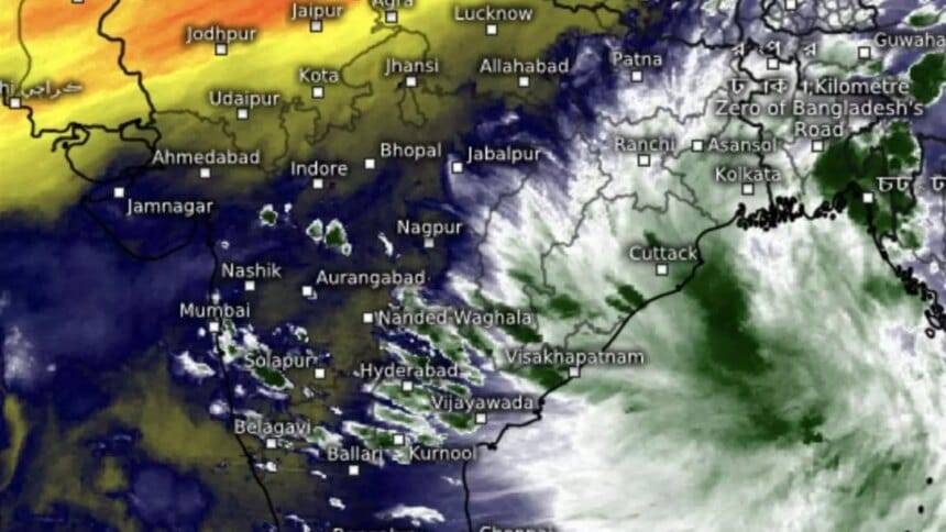
जून-सितंबर दक्षिण-पश्चिम मानसून सोमवार (सितंबर 30, 2024) को समाप्त हो गया, लेकिन, भारत मौसम विज्ञान विभाग (आईएमडी) ने पश्चिम बंगाल से दूर उत्तरी बंगाल की खाड़ी के ऊपर मानसून के बाद पहला कम दबाव का क्षेत्र बनने की संभावनाओं को अधिसूचित किया है। अगले दो दिनों में तट।
प्री-मॉनसून और मॉनसून के बाद के चरण बंगाल की खाड़ी और अरब सागर में तूफान बनने के जोखिम से भरे होते हैं, जो मॉनसून के ज़मीन से बाहर निकलने की गति पर निर्भर करता है। बुधवार तक, यह पूरे जम्मू-कश्मीर-लद्दाख में उत्तर-पश्चिम भारत के अधिकांश हिस्सों से हट गया था; हिमाचल प्रदेश; उत्तराखंड; पंजाब; हरियाणा-चंडीगढ़-दिल्ली; पश्चिमी राजस्थान के शेष भाग; पश्चिमी उत्तर प्रदेश के कुछ हिस्से; पश्चिम मध्य प्रदेश; और पूर्वी राजस्थान.
मानसून वापसी की रेखा
वापसी की रेखा लखीमपुर खीरी (उत्तर प्रदेश) से होकर गुजरी; शिवपुरी (मध्य प्रदेश); कोटा, उदयपुर और डीसा (राजस्थान); और सुरेंद्रनगर और जूनागढ़ (गुजरात)। आईएमडी ने पश्चिमी उत्तर प्रदेश के शेष हिस्सों से आगे की वापसी के लिए परिस्थितियों को अनुकूल माना; कुछ और भाग मध्य प्रदेश; पूर्वी राजस्थान के शेष भाग; गुजरात के कुछ और हिस्से; और अगले 2-3 दिनों के दौरान महाराष्ट्र के कुछ हिस्सों में।
-
यह भी पढ़ें: कृषि मंत्री चौहान ने किसानों की आय 10-20% बढ़ाने में मदद के लिए छोटे-छोटे मुद्दों को सुलझाने पर जोर दिया
यह संभवतः खाड़ी से उभरते हुए ‘निचले’ स्तर की ओर बढ़ सकता है, जिसके आंध्र प्रदेश की ओर पूर्वी तट के साथ-साथ दक्षिण-पश्चिम दिशा में आगे बढ़ने और तेलंगाना और निकटवर्ती विदर्भ की ओर बढ़ने का अनुमान है। यहां से, यह पूर्वी-मध्य भारत में मॉनसून की वापसी को रोक देगा, और 12 अक्टूबर, 2024 तक थोड़ा और तेज़ हो सकता है, जब तक पूर्वानुमान उपलब्ध नहीं होंगे। मॉनसून की वापसी के साथ आने वाली शुष्क उत्तर-पश्चिमी हवाओं को पश्चिम भारत में एक संक्षिप्त विराम लेने के लिए मजबूर होना पड़ेगा।
एमजेओ तरंग के अंदर आने की संभावना है
यूएस क्लाइमेट प्रेडिक्शन सेंटर के एक आउटलुक के अनुसार, यह वह समय है जब बारिश के अनुकूल मैडेन-जूलियन ऑसिलेशन (एमजेओ) हिंद महासागर में (9 से 22 अक्टूबर के दौरान) चलता है। इसने बंगाल की खाड़ी और अरब सागर दोनों को तूफान (कम दबाव क्षेत्र या अवसाद) बनने की 20-40 प्रतिशत संभावना के साथ निगरानी में रखा है। यह उत्तर-पूर्वी मानसून (रिवर्स मानसून या शीतकालीन मानसून) के आगमन की घोषणा करने की सामान्य खिड़की भी है, जो उत्तर-पूर्व (दक्षिण-पश्चिम से) हवाओं के उलट होने से चिह्नित होती है।
शुक्रवार तक ‘कम’ होने की संभावना है
“बुधवार को, एक ऊपरी वायु परिसंचरण दक्षिण-पूर्व बांग्लादेश पर बना हुआ था, एक ट्रफ रेखा म्यांमार तट से होते हुए उत्तरी अंडमान सागर तक जा रही थी। इसके प्रभाव के तहत, शुक्रवार के आसपास उत्तरी खाड़ी और आसपास के क्षेत्र में ‘लो’ बनने की संभावना है, ”आईएमडी ने कहा। गुरुवार को उत्तर-पूर्व क्षेत्र में अलग-अलग स्थानों पर भारी से बहुत भारी बारिश होने की संभावना है और पश्चिम बंगाल की पहाड़ियों पर अलग-अलग स्थानों पर भारी बारिश होने की संभावना है; शुक्रवार को पश्चिम बंगाल के मैदानी इलाके; शुक्रवार और शनिवार को उत्तर-पूर्व क्षेत्र; और असम एवं मेघालय पर; नागालैंड; मणिपुर; मिज़ोरम; और त्रिपुरा रविवार से मंगलवार तक।
पूर्व, दक्षिण में बारिश का अनुमान
कुल मिलाकर, अगले सात दिनों तक उत्तर-पूर्व में काफी व्यापक से मध्यम बारिश होने की संभावना है। यह बिहार, पश्चिम बंगाल और सिक्किम में काफी व्यापक रूप से बिखरा हुआ होगा और झारखंड और ओडिशा में अलग-थलग से लेकर मध्यम तक फैला होगा।
दक्षिण प्रायद्वीप में, रविवार तक तमिलनाडु, पुडुचेरी और कराईकल में छिटपुट भारी बारिश की संभावना है; और गुरुवार को केरल और माहे में। यह केरल और माहे में काफी व्यापक से व्यापक से मध्यम तक होगा; दक्षिण आंतरिक कर्नाटक; और आने वाले सप्ताह के दौरान लक्षद्वीप, और तमिलनाडु, पुडुचेरी और कराईकल में काफी व्यापक से मध्यम तक बिखरा हुआ; तटीय कर्नाटक उत्तर आंतरिक कर्नाटक। यह तटीय आंध्र प्रदेश और यनम में अलग-थलग से लेकर मध्यम तक बिखरा हुआ रहेगा; रायलसीमा; और तेलंगाना.
-
यह भी पढ़ें: ऑयल पाम किसान एफएफबी कीमतों में बढ़ोतरी से खुश हैं, लेकिन स्थिर रिटर्न चाहते हैं
Complete News In English(पूरी खबर – अंग्रेज़ी में)
The southwest monsoon came to an end on Monday, September 30, 2024, but the India Meteorological Department (IMD) has indicated that a low-pressure area could develop over the northern Bay of Bengal in the next two days.
After the monsoon season, both the Bay of Bengal and the Arabian Sea pose risks for storm formation, depending on how quickly the monsoon recedes. By Wednesday, the monsoon had mostly exited from parts of Jammu-Kashmir, Ladakh, Himachal Pradesh, Uttarakhand, Punjab, Haryana-Chandigarh-Delhi, western Rajasthan, parts of western Uttar Pradesh, western Madhya Pradesh, and eastern Rajasthan.
### Monsoon Withdrawal Line
The withdrawal line passed through locations like Lakhimpur Kheri (Uttar Pradesh), Shivpuri (Madhya Pradesh), Kota, Udaipur, and Disa (Rajasthan), extending to Surendranagar and Junagadh (Gujarat). The IMD has deemed the conditions favorable for further withdrawal across the remaining parts of western Uttar Pradesh, some more areas in Madhya Pradesh, eastern Rajasthan, other parts of Gujarat, and some regions in Maharashtra over the next 2-3 days.
This low-pressure area might move towards Andhra Pradesh and then south-west, potentially affecting Telangana and Vidarbha. It is expected to slow down the monsoon’s retreat in central India, and this lingering pattern may continue until around October 12, 2024, subject to further forecasts.
### Madden-Julian Oscillation (MJO) Impact
According to the US Climate Prediction Center, during the period from October 9 to 22, the Madden-Julian Oscillation (MJO) will create conditions favorable for rain across the Indian Ocean, which may lead to the formation of storms in both the Bay of Bengal and Arabian Sea with a 20-40% likelihood. This period generally signals the arrival of the northeast monsoon, characterized by a reversal of winds.
### Expected Weather Developments
The IMD noted that by Wednesday, a weather pattern was forming over southeast Bangladesh, with a trough extending towards the northern Andaman Sea. As a result, the northern Bay of Bengal region could see low-pressure development around Friday. Heavy rainfall is expected in different parts of the northeastern region, West Bengal, and several states from Sunday to Tuesday, including Assam, Meghalaya, Nagaland, Manipur, Mizoram, and Tripura.
### Overall Rainfall Expectations
Over the next week, substantial rainfall is anticipated in the northeastern states, with widespread medium rain likely in Bihar, West Bengal, and Sikkim, and moderate rainfall scattered across Jharkhand and Odisha. In southern India, sporadic heavy rain is expected in Tamil Nadu, Puducherry, and Karaikal until Sunday and in Kerala on Thursday.
Overall, significant rainfall is forecasted throughout various regions, primarily focused on the eastern and southern parts of India.
Source link