

Main Points In Hindi (मुख्य बातें – हिंदी में)
-
मानसून की वापसी: दक्षिण-पश्चिम मानसून जून से सितंबर में अपनी वापसी पूरी करेगा और संभवतः अक्टूबर के दूसरे सप्ताह में उत्तर-पूर्वी मानसून की तैयारी करेगा, विशेष रूप से तमिलनाडु, केरल और आंध्र प्रदेश में।
-
हवा की दिशा में बदलाव: 8-9 अक्टूबर के मध्य से दक्षिण-पश्चिमी हवाओं का उत्तर-पूर्वी हवाओं में परिवर्तन होगा, जिससे चक्रवाती परिसंचरण की शुरुआत हो सकती है, विशेषकर अरब सागर में।
-
अधिक वर्षा की उम्मीद: आईएमडी के अनुसार, अक्टूबर से दिसंबर के बीच दक्षिण प्रायद्वीप में सामान्य से अधिक वर्षा की आशंका है, जिसमें केरल, तमिलनाडु और आंध्र प्रदेश शामिल हैं। यह क्षेत्र विशेष रूप से तटीय आंध्र प्रदेश और तमिलनाडु-पांडिचेरी के लिए महत्वपूर्ण है।
-
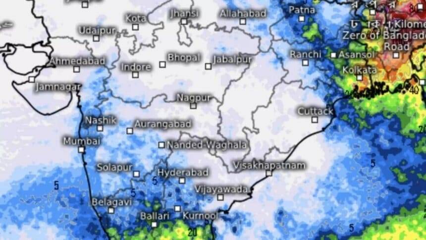
कम दबाव का क्षेत्र: पश्चिम बंगाल और दक्षिण-पश्चिम बांग्लादेश में कोई भी समय कम दबाव का क्षेत्र बन सकता है, जिसके परिणामस्वरूप बारिश की गतिविधियों में वृद्धि हो सकती है।
- 10 अक्टूबर से वर्षा की संभावना: 10 अक्टूबर से शुरू होने वाले सप्ताह के दौरान तमिलनाडु और केरल में भारी बारिश की संभावना है, जबकि पूर्वी भारत के अन्य क्षेत्रों में भी भारी वर्षा हो सकती है।
Main Points In English(मुख्य बातें – अंग्रेज़ी में)
Here are the main points from the provided article about the monsoon in India:
-
Withdrawal of the Southwest Monsoon: The southwest monsoon is expected to complete its withdrawal by mid-October, paving the way for the northeastern monsoon to potentially begin in Tamil Nadu, Kerala, and parts of Andhra Pradesh by October 15, as forecasted by the India Meteorological Department (IMD).
-
Change in Weather Patterns: Numerical models indicate that starting October 8-9, southwestern winds will gradually transition to northeastern winds, which will dominate regions such as the Bay of Bengal, South Peninsula, and Arabian Sea, with a cyclonic circulation being established.
-
Above Average Rainfall Forecast: IMD predicts that seasonal rainfall during the northeastern monsoon period (October to December) will exceed normal levels, with an anticipated 112% of the long-term average, especially impacting coastal regions of Andhra Pradesh, Rayalaseema, and Tamil Nadu.
-
Development of a Low-Pressure Area: The IMD is monitoring the potential formation of the first low-pressure area post-monsoon over West Bengal’s coastal regions and adjoining South-West Bangladesh, with an expected impact on weather patterns.
- Heavy Rainfall Expected: From October 10, sporadic heavy rainfall is likely in regions such as Tamil Nadu and Kerala, with significant rain also anticipated in parts of northeastern and eastern India, including Arunachal Pradesh, Assam, Meghalaya, and parts of West Bengal.

Complete News In Hindi(पूरी खबर – हिंदी में)
जून-सितंबर में दक्षिण-पश्चिम मानसून अपनी वापसी पूरी कर सकता है और अक्टूबर के दूसरे सप्ताह में भूमि से बाहर निकल सकता है, जो संभवतः तमिलनाडु, केरल और आंध्र प्रदेश के कुछ हिस्सों में उत्तर-पूर्वी मानसून के आगमन के लिए मंच तैयार करेगा। 15 अक्टूबर, भारत मौसम विज्ञान विभाग (IMD) ने अगले पखवाड़े के लिए मौसम के पूर्वानुमान में कहा है।
मौसमी हवाओं का उलटा होना
संख्यात्मक मॉडल भविष्यवाणियों से पता चलता है कि अगले सप्ताह (8-9 अक्टूबर) के मध्य से दक्षिण-पश्चिमी हवाएं धीरे-धीरे उत्तर-पूर्वी हवाओं का मार्ग प्रशस्त करेंगी। कभी-कभार ब्लिप्स को छोड़कर, यह प्रवृत्ति अगले तीन-चार दिनों के दौरान बंगाल की खाड़ी, दक्षिण प्रायद्वीप और अरब सागर पर हावी होने के संकेत दिखाती है, जब तक कि खाड़ी में एक चक्रवाती परिसंचरण और एक समकक्ष परिसंचरण द्वारा पूर्वी लहर समाप्त नहीं हो जाती। अरब सागर संभवतः उत्तर-पूर्वी मानसून की शुरुआत करता है।
सामान्य से अधिक वर्षा
आईएमडी ने रिकॉर्ड पर कहा है कि दक्षिण प्रायद्वीप में अक्टूबर और दिसंबर (उत्तर-पूर्व मानसून अवधि) के बीच मौसमी वर्षा, जिसमें केरल, तमिलनाडु और आंध्र प्रदेश शामिल हैं, सामान्य से ऊपर होने की उम्मीद है, जो कि लंबे समय की 112 प्रतिशत है। -अवधि औसत 33.4 सेमी. यह विशेष रूप से तटीय आंध्र प्रदेश, रायलसीमा और तमिलनाडु-पांडिचेरी के मौसम संबंधी उपखंडों के लिए प्रमुख मौसमी बारिश है।
-
यह भी पढ़ें: ऑस्ट्रेलियाई मौसम एजेंसी का कहना है कि ला नीना के उभरने का कोई निरंतर संकेत नहीं है
आंतरिक कर्नाटक, केरल और लक्षद्वीप के लिए – जिसने पिछले दक्षिण-पश्चिम मानसून के दौरान अधिकतम लाभ कमाया था – दिसंबर तक बारिश जारी रहती है। उत्तर-पूर्वी मानसून इन मौसम संबंधी उपविभागों में वार्षिक कुल का लगभग 20 प्रतिशत योगदान देता है।
जल्द ही निम्न दबाव का क्षेत्र बनेगा
इस बीच, आईएमडी ने पश्चिम बंगाल के तटीय इलाकों और इससे सटे दक्षिण-पश्चिम बांग्लादेश पर किसी भी समय मानसून के बाद का पहला कम दबाव का क्षेत्र बनने पर नजर बनाए रखी है। दक्षिण-पश्चिम बांग्लादेश पर एक प्रारंभिक परिसंचरण बना हुआ है, शुक्रवार की सुबह एक ट्रफ रेखा उत्तर-पूर्व बिहार से उत्तरी अंडमान सागर तक फैली हुई है। यह ‘निम्न’ बनाने के लिए निचले स्तरों तक उतरेगा। एक और चक्रवाती हवाओं का क्षेत्र लक्षद्वीप और उसके आसपास मंडरा रहा है।
-
यह भी पढ़ें: भारत का दक्षिण-पश्चिम मानसून सामान्य से 8% अधिक बारिश के साथ समाप्त हुआ
कुछ स्थानों पर भारी वर्षा की संभावना
10 अक्टूबर से शुरू होने वाले सप्ताह के दौरान तमिलनाडु और केरल में छिटपुट भारी बारिश होने की संभावना है। इसके साथ ही, मध्य, पूर्व और पूर्वोत्तर भारत और दक्षिण प्रायद्वीप में छिटपुट से लेकर काफी व्यापक बारिश हो सकती है। यह पूर्वी और उत्तर-पूर्व भारत में अरुणाचल प्रदेश, असम और मेघालय और पश्चिम बंगाल और सिक्किम की पहाड़ियों पर भारी से बहुत भारी और पश्चिम बंगाल, ओडिशा, झारखंड और बिहार के मैदानी इलाकों में भारी रूप से भारी होगा।
Complete News In English(पूरी खबर – अंग्रेज़ी में)
The southwest monsoon is expected to complete its withdrawal between June and September, exiting the land by the second week of October. This sets the stage for the arrival of the northeast monsoon in parts of Tamil Nadu, Kerala, and Andhra Pradesh by October 15, according to the India Meteorological Department (IMD).
### Changes in Seasonal Winds
Numerical weather models suggest that from the middle of the week (October 8-9), the prevailing southwestern winds will gradually shift towards northeastern winds. Excluding some minor fluctuations, this trend is expected to dominate over the next three to four days across the Bay of Bengal, the southern peninsula, and the Arabian Sea. This shift may pave the way for the northeastern monsoon.
### Above Normal Rainfall
The IMD predicts that seasonal rainfall during the northeast monsoon (October to December), which includes states like Kerala, Tamil Nadu, and Andhra Pradesh, is expected to be above normal—112% of the long-term average, which is 33.4 cm. Coastal Andhra Pradesh, Rayalaseema, and parts of Tamil Nadu-Puducherry might see significant rainfall.
### Formation of a Low-Pressure Area
Meanwhile, the IMD is monitoring the potential formation of a post-monsoon low-pressure area over coastal West Bengal and southwest Bangladesh. An initial circulation is forming over southwest Bangladesh, with a trough extending from northeast Bihar to northern Andaman Sea. This could contribute to the formation of a ‘low’ in the area, while another cyclonic circulation is hovering around Lakshadweep.
### Chances of Heavy Rain in Some Areas
During the week starting October 10, scattered to heavy rainfall is likely in Tamil Nadu and Kerala. Additionally, other regions in central, eastern, and northeastern India, as well as the southern peninsula, may experience varying degrees of rainfall, with heavy to very heavy rains expected in Arunachal Pradesh, Assam, Meghalaya, and the hills of West Bengal and Sikkim. Heavy rainfall is also anticipated in the plains of West Bengal, Odisha, Jharkhand, and Bihar.
Source link